The Meetjesland in the north of East-Flanders, Belgium
Balgerhoeke, a Meetjesland town
Where does this name come from? Opinions vary widely.
Inspector Ryserhove wrote in "Oud Eeklo" (Old Eeklo) that originally (in 1350 that is) they wrote Balverhouche. A "balg" is a bag or a net. A "were" is a dam and there is no dispute about the word "hoek" which means corner. In other words a place where there was a net and/or a dam in the river, surely to catch fish.
 According to Snellaert (1806 - 1872) this was Balfaertshoek,
Balfaert's place. The "Balfaert" was a customs duty the boatmen
on the Lieve river had to pay to pass through this place.
According to Snellaert (1806 - 1872) this was Balfaertshoek,
Balfaert's place. The "Balfaert" was a customs duty the boatmen
on the Lieve river had to pay to pass through this place.
Gheldolf, an archaeologist, says the name comes from balfort. The balfort was an old Roman tax for the lord. Here it would have been paid to the lord of the "Hof te Praet" (Praet's Farm). This inevitably became also a French tax and later also a tax levied by the Duchy of Flanders.
Kervijn de Lettenhove thinks the name comes from bal (house or dwelling), ward (guardian) and hoek.
Yet another person claims Balgerhoeke or Balfort means the place where the "dodenbrand", burning of the dead or burning for the dead was celebrated by our heathen forbears.
The famous priest Sanderus wrote "Balle Verboecke" or Bede Verbroeke" on a few of the maps in his famous Flandria Illustrata. But those were no doubt vulgarisms.
On a map in the Bruges city hall we read Ballegeershoeke, rather similar to "Balle", "weer" or "were" and "hoeke".
And finally Balger perhaps means the inhabitants of "balgoy" which simply means higher ground close to the water. So much for the etymology of the name.
 There are traces of prehistoric occupation by humans here.
People lived here also when the Romans ruled. We can be very sure of that
because when they dug the Schipdonk Canal at the end of the 19th Century they
found what amounts to a Roman graveyard somewhere north of the Malecote Farm.
If someone had heard of the study of the remains of cultures past no one thought
of calling in a team of archaeologists. They just simply threw together the
old pottery and what not and carried on digging the canal as if nothing special had
occurred.
There are traces of prehistoric occupation by humans here.
People lived here also when the Romans ruled. We can be very sure of that
because when they dug the Schipdonk Canal at the end of the 19th Century they
found what amounts to a Roman graveyard somewhere north of the Malecote Farm.
If someone had heard of the study of the remains of cultures past no one thought
of calling in a team of archaeologists. They just simply threw together the
old pottery and what not and carried on digging the canal as if nothing special had
occurred.
That's why we don't know the exact spot where these Gallo-Roman objects were found and of course no inventory of the finds was made. Fortunately Mr. Neelemans, Eeklo's burgomaster, bought up that old stuff and thanks to him you can now admire some of those Roman pots, crocks, jars, drinking goblets and oil lamps in an old-fashioned—read marvelous—museum called Gruuthuse in Bruges. It's worth the trip just to see that old building from the inside. In any case you should go see this wonderful old city for yourself or go back if you have been there already. This museum and the whole old city really are marvellous and if you search really carefully you may still find here on this website a money back garanty, ;) that's how sure we are you will love Bruges and her museums and most everything else.
The arrival of the Romans brought radical changes for our ancestors and their way of life. They learned all about linen, woven fabrics, pottery and how to build houses with windows. What's more, the Romans imported new varieties of grain with as a result an improvement in agriculture and no doubt temporarily a higher standard of living.
The northern part of our country was covered with woods, grazing land and—due to bad drainage and numerous inundations—marshes.
The Morini and Manapii who lived in our regions built their huts on higher ground in the middle of the woods to prevent flooding. They sought out sandhills or old sea dunes. One of those sea dunes ran from Ter Strepen (now Ostend) via Bruges, Maldegem, Balgerhoeke, Eeklo, Lembeke all the way to Antwerp.
It is on this sandy ridge that Eeklo and Balgerhoeke were founded. Down these hills there were the marshes and ditches that evacuated the water to the sea inlets. There are many places with "moer" (marsh) as part of their name: Zuidmoerstraat (South Marsh Road), Moerwege, ("weg", "wege" = road) Moerhuize ("huis" = house), Pokmoere, Moerkerke ("kerk" = church), Moershoofde...
In the year 631 Balgerhoeke looked like a small slowly developing village. That's when Saint Amandus came from the far away Acquitaine region of France (Bordeaux) to preach and to convert the Pagus Flandrensis (Flanders Country) to the Christian faith. He built two monasteries in Ghent. A few years later he was succeeded by Saint Eligius. We may safely say that Flanders has these two saints to thank for her Christian faith.
The people of Balgerhoeke went to Eeklo or to Adegem to fulfill their religious obligations and this state of affairs was to last until 1902 when at last Balgerhoeke became a separate parish with the Reverend Eduardus Bernardus Bonte as its first priest. (Here we have his funeral card.)
But after St. Amandus and St. Eligius, and for a long time... nothing. No news about or from Balgerhoeke.
When Charles the Good was Count of Flanders Raverschoot flourished. Raverschoot was in what is now Adegem (where you can read more about its dramatic end). Balgerhoeke had quite a population and was an important town. After his death in 1127 Raverschoot was burned down and completely destroyed never to be rebuilt. The inhabitants of Raverschoot sought refuge around the Fortress (Slot) of Eeklo and eventually settled there and for a while Eeklo was a boom town, a center of commerce and industry. Balgerhoeke belonged to what was called "Eeklo-Buiten", in contrast to Eeklo-Binnen ("Buiten" is outside and as you already guessed "binnen" is inside.)
From the year 1227 on documents mention the name Balgerhoucke.
When Eeklo obtained it charter in 1240 there existed two insignificant hamlets on its western side; one of them was Balgerhoeke. It had been founded on the "Molengracht" (Mill Ditch), later called the Lieve River on the road from Kaprijke to Bruges and near the even older Raverschoot on the higway from Bruges to Antwerp.
In a 1439 document in the Archives of the Bishopric of Ghent we read about the "Grote Balgerouc strate" ("groot" or "grote" is big, grand and "straat" or "strate" is street, road).
Fast forward to 1824 when the Dutch ruled since the defeat of Napoleon in 1815. The first local fair ("kermis") attracted undoubtedly a lot of people to Balgerhoeke. Perhaps one of the attractions was then already the horse driven merry-go-round. To this would later be added the cyclocross, the games such as football and many other attractions.
We know of 4 inns in Balgerhoeke between 1820 and 1830: "Het Lam" (The Lamb), "Het Koophandelshuys" (The House of Commerce), "In den Papegaey" (In the Parrot) and "Den Tijd" (The Time). In 1900 there were 121 inhabitants who lived in 50 houses. And that, says Madeleine Van Volsem, was about one tenth of the number of people living in Balgerhoeke when she published here booklet in 1983.
In 1902 Balgerhoeke became an separate parish and on 9 July 1902 the Reverend Eduard Bernard Bonte became its first village priest. (Here is his picture on his funeral card.) In 1905 and the next year the current neogothic church was built according to plans drawn up by architect Modest De Noyette. In 1918 the church suffered heavy war damage. This was repaired in 1919 and in 1920. In 1940 the church spire is blown up not without damage to the rest of the church. By 1941 this "collateral" damage was repaired. But in 1944 the roof was set on fire and the vault collapsed. This damage was repaired by 1950 and in 1960 the church spire was rebuilt for the third time in 60 years.
The town is on the borders of the Schipdonk Canal. The Canadians fought
hard and valiantly here in 1944 to cross the canal and liberate our Meetjesland.
Balgerhoeke was liberated by the South Alberta Regiment.
Here is a list of the men
of that regiment who died in action and were buried in the
Adegem Canadian War Cemetery. One of them is
Antoon Devreker.
He was born in West-Flanders, not so far from here. His parents emigrated to
Canada before the war.
 |
 |
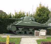
When the fighting for the liberation of Balgerhoeke (and Eeklo) was over on 15 September 1944 much of the town, including the church was in ruins. Now all that has gone. The town and its church are looking very well. Just before we cross the bridge coming from the center of Balgerhoeke we come upon a monument in honour of the Canadians who gave us back our freedom: a Sherman tank.
Balgerhoeke is administratively a part of Eeklo.
It has never been an independent town with its own burgomaster and town council.
The source for most of the above is a marvelous booklet written in 1983 by Madeleine Van
Volsem who has lived all her life in Balgerhoeke. We would have liked her to know that
we have not forgotten her and her work but unfortunately she passed away on 14 July 2000.
Many thanks also to Mr. Marnix Van de Kerckhove who unearthed a copy of her booklet for us.
Talk about a harebrained scheme ! Who are those people who want to widen and deepen
the Schipdonk Canal, take great swathes of good agricultural land on both sides of the canal and
transform them into an industrial wasteland, destroying the unique beauty of it all ?
We're not surprised so many people are against this addlepated scheme.
More recent pictures from Balgerhoeke
Pictures of war damaged Balgerhoeke in 1940

More pictures
Our Meetjesland
— Table of Contents
— Find something in this Meetjesland website

MijnPlatteLand.com
Most recent update : 05-03-2023
Copyright Notice (c) 2026