The Meetjesland in the north of East-Flanders, Belgium
Our Meetjesland
Why not start this story in the Stone Age with a quote from a great book about a great Meetjesland town called Watervliet. The book is in Dutch and I translated its name as "Watervliet, a King's Wish and a Knight's Dream".
On page 12 we read:
"In the Stone Age the region of the Scheldt Polders looked like a vast inland lake into which the Scheldt discharged itself. It is said that in the days of the Old Belgians and the start of the Roman Occupation, this inland lake had gradually been transformed into a swampy and very inhospitable region. The Menapians had chosen to live to the west of the Scheldt river and their domain reached to the Meuse (Maas). Meanwhile this situation confirms a statement by Caesar who claimed the Scheldt flowed not into the sea but into the Meuse river. When about 1200 most peat villages in the region came into being, the areas of higher ground were of course very important."
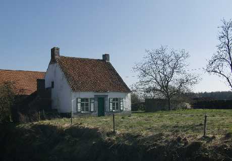
An old farm.
The name "Meetjesland" is according to some a fairly recent invention: they claim it is perhaps not more than 2 centuries old. In any case, we are not talking here about a historic region. The word "Meetjesland" is pronounced a bit like Mate-yes-land except that the "e" in that -yes- is pronounced like the e in "the" and the a in "land" is pronounced like the a in "March". (Here is a more comprehensive (but not very authoritative) guide to the pronunciation of Dutch words.)
Yes, but where is this?
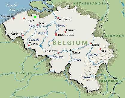 |
See the green dot north-east of Ghent and west of Brugge (Bruges) ? There it is, our Meetjesland, right up against the Dutch border. |
Belgium with its 11,787 square miles is about 312 times smaller than the USA. And our Meetjesland is perhaps a fiftieth part of Belgium. It lies east of Bruges (Brugge).
The northeastern part of our Meetjesland with Ursel, Maldegem, Middelburg, Adegem, St. Laureins, St. Jan-in-Eremo, St. Margriete, Waterland-Oudeman, Watervliet, Kaprijke, Balgerhoeke, Eeklo and Lembeke came under the authority of the Freedom of Bruges (the "Brugse Vrije").
 In the eastern
part of the Meetjesland we have most of the Four Corporations:
Bassevelde,
Boekhoute and
Oosteeklo were part of the Boekhoute Corporation.
Assenede,
Ertvelde,
Kluizen,
Zelzate,
Wachtebeke and
St. Kruis-Winkel were part of the old Assenede
Corporation. The southern part with
Aalter,
Knesselare,
Oostwinkel,
Zomergem,
Ronsele,
Waarschoot,
Sleidinge,
Evergem, Wondelgem, Mariakerke,
Vinderhoute,
Lovendegem,
Merendree,
Hansbeke and
Bellem belonged to Ghent ("Oudburg Ghent").
As far as the language is concerned they also speak a very different dialect, for instance in
Maldegem and in
Assenede.
In the eastern
part of the Meetjesland we have most of the Four Corporations:
Bassevelde,
Boekhoute and
Oosteeklo were part of the Boekhoute Corporation.
Assenede,
Ertvelde,
Kluizen,
Zelzate,
Wachtebeke and
St. Kruis-Winkel were part of the old Assenede
Corporation. The southern part with
Aalter,
Knesselare,
Oostwinkel,
Zomergem,
Ronsele,
Waarschoot,
Sleidinge,
Evergem, Wondelgem, Mariakerke,
Vinderhoute,
Lovendegem,
Merendree,
Hansbeke and
Bellem belonged to Ghent ("Oudburg Ghent").
As far as the language is concerned they also speak a very different dialect, for instance in
Maldegem and in
Assenede.
Consequently, a short general history of the Meetjesland is well nigh impossible, but we will try and tell you a little about each one of its villages.
 |
Our modern farm animals teach each other to pump their own drinking water. And now watering places like this one have all but disappeared. |
The Meetjesland is not a geographical unit either: in the north we have the polders, an exceptional landscape, wholly man made. During a great storm more than 6 centuries ago, the salty water of the Westerscheldt inundated the land. That terrible catastrophy in that November 1377 night has been called the Elisabeth Flood.
For more than a century nothing changed here except the alternation of the tides. Then our ancestors began to reconquer the land: dykes were built, surrounding square, rectangular or irregularly shaped fields and on the dykes they planted poplars. These trees grew fast; their roots went deep into the ground, they strengthened the dykes and kept them together against the violence of the sea. Boekhoute in the northern part of our Meetjesland was once upon a time a fishing port. It is miles away from the sea now.
Here and there the violent waters dug deep gullies and that's how our creeks ("kreken") were formed when the sea retreated. These lakes, surrounded with reeds and perhaps with a row of pollard-willows are now part of the quiet beauty of the landscape together with the dikes and the flat land.
Here and there you may still come upon an old barn with its roof perhaps reaching almost to the ground, with a much smaller farmhouse nearby and a few fruit trees. The polders of the Meetjesland with their clay-soil are great agricultural land.
A little more to the south you will see the Leopold Canal. It was built shortly after Belgium won its independence to permit a better drainage of the polders without the help of the Dutch to the north. And on the other side of the canal we soon come to the "Houtland" ("Hout" = Wood) with its more sandy soil. About 5% of our Meetjesland is covered by woods.
Below you see a piece of an old Ferraris map. It shows clearly the polders region with its larger fields compared to the Woodland.

Here too the land has its own value. You will see here the small labourers houses with their low tiled roofs, white chalked facades, small windows and surrounded with a thorny hedge.
The fields and meadows here in the old days were very small. More often than not these narrow strips of land were separated by ditches with or without pollard-willows around them. Let's not forget that before coal, wood was very important for heating and for cooking. (In a great pot suspended from a boom over a log fire beans and potatoes were cooked for the whole family and for the animals.) Nowadays the orchards with their tall trees around the farmhouses have mostly disappeared; and on many farms you see practically no animals.
 |
Poplars along the Leopold Canal. |
In the southern and eastern parts of the Meetjesland you have industrial enterprises providing jobs and perhaps also some pollution.
Finally, unlike our towns or provinces, our Meetjesland doesn't have exact borders. Perhaps some natives from Zelzate, Wachtebeke, St Kruis-Winkel in the east, or Merendree and Vinderhoute in the south don't consider themselves Meetjeslanders. We will use the description as it was given by dr. E. Tieleman in the magazine of regional geography and history called "Appeltjes van het Meetjesland" ("Appels from the Meetjesland"), 1949, p. 5-9 and 29-49: it is more or less the region between the Dutch border, the Ghent-Terneuzen Canal, the Ring Canal (around Ghent), the Ghent-Bruges Canal and the border with West Flanders.
And now, what does the name "Meetjesland" mean? There is no lack of explanations:
- Father Constant Duvillers, a Catholic priest, says in his "Almanac of the Meetjesland" (1862) that it means the land of the old women. Apparently when Emperor Charles travelled through our region he was amazed to see so many old women, spinning, sewing and knitting in front of their houses. And Dr. E. Tieleman, who extensively researched the origins of the name Meetjesland claims it has not been found in publications older the the "Almanack of the Meetjesland". Was the name perhaps invented by Fr. Duvillers ?
- August Van Acker, secretary of the city of Eeklo thought it was a transformation of Métiers-land, i.e. the land of the weaving-looms. Perhaps the cottage industry of weaving was more widespread here.
- Others think it comes from the words "meete" or "gemete". One "gemete" is roughly an acre. In the Meetjesland, they claim, people used the "mete" and "gemete" as a unit of measurement whereas in other regions they spoke of "dagwand" or "bunder".
- Ivan Hoste also touches on the subject in the excellent "Streekgids Meetjesland" (Regional Guide Meetjesland", a beautiful and well researched book published in 1998 by "Natuur en Landschap Meetjesland vzw" (Nature and the Meetjesland Landscape), a non profit association. The great blocks of land that were bought up for the peat extraction were called "maten" or "meten" which were divided in long narrow strips, maatjes" or "meetjes". The suffixes "je", plural "jes" or "ke", "ken", plural "kens" are similar to the French "ette" (fille, fillette), the German "chen" (Madchen") and the English "let" (like in piglet). Sint-Jan was also called Sint-Jan-in-de-Mate. St-Laureins in the 16th Century was called Sint-Laureins-ten-Blokke. "In de mate" and "ten Blokke" were synonymous. North of Eeklo there were two or three "maten" villages. To prove that was the origin of the name Meetjesland you must prove that the name was used (even if for a much smaller region than today) during the decenia of the peat industry and ever since. But once that layer of peat was dug out nothing remained except the worthless sandy land that lay fallow like a desert. Sint-Jan then became Sint-Jan-in-Eremo, which means "in the wasteland". "Meet", "mede" or "medeken" means a rectangular parcel of land. These and similar words were used especially around St Laureins where we still have the name "Mekensakker" ("akker" means field). And in Balgerhoeke we have the Mekenstraat ("straat" is street).
There were more explanations, some more fantastic than others. Some were also applicable to other regions.
Whatever the meaning of its name, our Meetjesland has its place in Flanders. It's here that our family lived, worked and suffered. Here they were married. Here they died and here so many are buried. And here the descendants of so many of those who emigrated like to come back.
More pictures
Here is a list of all our Meetjesland towns.
Travel instructions: how to come to our
Meetjesland.

Our Meetjesland
— Table of Contents
— Find something in this Meetjesland website

MijnPlatteLand.com
Most recent update : 02-05-2021
Copyright Notice (c) 2026